Skyline-to-the-Sea Trail
| Skyline-to-the-Sea Trail | |
|---|---|
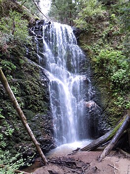
 The 70 ft. (21 m) Berry Creek Falls, as seen from the wooden viewing platform | |
| Length | 29.5 mi (47.5 km) |
| Location | Santa Cruz County, California, USA |
| Trailheads | Saratoga Gap, California Waddell Beach, Pacific Ocean Castle Rock State Park California |
| Use | Hiking |
| Elevation change | 2,600 ft (790 m) |
| Highest point | Saratoga Gap, 2,600 ft (790 m) |
| Lowest point | Waddell Beach, 0 ft (0 m) |
| Difficulty | Moderate |
| Season | May 1st through November 1st |
| Sights | Castle Rock State Park Big Basin State Park |
| Hazards | Severe Weather |
The Skyline-to-the-Sea Trail is a 29.5-mile (47.5 km) hiking trail that descends from the ridge of the Santa Cruz Mountains in California to the Pacific Ocean, passing through Castle Rock State Park and Big Basin Redwoods State Park. Big Basin is California's oldest state park. It contains beautiful waterfalls and some of the largest, tallest, and oldest Redwood forests left in existence.[citation needed]
History
[edit]The trail was started in 1969 by the Sempervirens Fund of Conservation Associates of the Sierra Club and was extended to the Pacific with the acquisition of part of the Hoover Ranch.[1] Planning began in 1968,[2] with the initial trail segment planned to follow the state-controlled right-of-way along SR 9, linking Saratoga Gap to Big Basin.[3] Local Boy Scouts participated in building the trail;[4] a "trail breaking party" was scheduled for April 1969.[5]
The final segment, extending the western terminus to the Pacific Ocean at Waddell Beach, opened in July 1978. It traverses the Rancho del Oso area of Big Basin, which was acquired by the state in 1977.[6]
After the August 2020 CZU Lightning Complex fires, the trail closed, along with much of Big Basin Redwoods State Park. As of December 2021, the trail remains closed and its future is unclear.[7][8]
Route
[edit]
The trail begins at Saratoga Gap on the ridge at the intersection of SR 9 and Skyline Boulevard (SR 35). The trail parallels SR 9 through Castle Rock, crosses the highway, and then follows SR 236 to Big Basin park headquarters. It then descends through Big Basin, following Waddell Creek to its outlet at Waddell Beach, for a total distance of approximately 25 mi (40 km).[9]
However, many hikers actually begin further southeast at Castle Rock due to its overnight parking facility; starting from Castle Rock, hikers first use the Saratoga Gap Trail, then the Travertine Springs Trail, joining Skyline-to-the-Sea at Beekhuis Road; this adds approximately 3 mi (4.8 km) to the total hiking distance.[9]
The trail usually takes two to three days to complete, with nearly all thru-hikers traveling from East to West (towards the ocean); typically hikers camp at Waterman Gap, approximately 6 mi (9.7 km) from Saratoga Gap, and Jay Camp, near the Big Basin headquarters, approximately 9 mi (14 km) from Waterman Gap.[9] Many hikers like to take a detour up Berry Creek Trail to see the waterfalls or to camp at Sunset Trail Camp, adding 2.7 mi (4.3 km) to the hike.[9] It is possible to walk the entire trail in one day, though this is unusual and very difficult.
A 50 km (31 mi) ultramarathon is held on this trail, starting from Saratoga Gap, one or two times per year, which features an elevation gain of 3,000 ft (910 m) and loss of 5,880 ft (1,790 m).[10]
Santa Cruz Metro routes 35 and 40 formerly went from Big Basin State Park Headquarters to Waddell Creek and back. Since September 2011, Route 40 no longer goes all the way to Waddell Beach from mid-December to mid-March.[11] but instead turns around at Cement Plant Rd. Route 35 formerly stopped at Big Basin Headquarters on the weekends during the Spring/Summer season.
As of October 2020, there is a 3.6 mi (5.8 km) extension that creates a "Saratoga-to-the-Sea" Trail.[12] The trail originates at Saratoga Quarry Park, and terminates at Sanborn-Skyline County Park. This trail connects to the Skyline-to-the-Sea Trail via a completed section of the Bay Area Ridge Trail. The park is owned by the city of Saratoga's Parks Department.[13]
-
The Skyline-to-the-Sea Trail passing through a fallen California Redwood tree.
-
The Skyline-to-the-Sea Trail passing over Waddell Creek.
References
[edit]- ^ "Skyline-to-the-Sea Trail". Sempervirens Fund. Retrieved 18 November 2024.
- ^ "Redwoods For The Future [Editorial]". Santa Cruz Sentinel. September 20, 1968. Retrieved 18 November 2024.
It is also proposed to link the new Castle Rock state park, the latest addition in the state park system, with historic Big Basin by the development of permanent trails.
- ^ "A Place Where Families Visit". Santa Cruz Sentinel. September 12, 1968. Retrieved 18 November 2024.
- ^ Witherell, Don; Witherell, Phila (August 2, 1969). "Weekend Walk: New Castle Rock Park". Oakland Tribune. Retrieved 18 November 2024.
- ^ "'Trail Breaking Party' Scheduled By Sierra Club At Big Basin Park". Santa Cruz Sentinel. March 30, 1969. Retrieved 18 November 2024.
- ^ Siebenthal, Denise (July 16, 1978). "There's A New World At Your Fingertips". Santa Cruz Sentinel. Retrieved 18 November 2024.
- ^ "Big Basin Redwoods SP". CA State Parks. Retrieved 2021-12-30.
- ^ "Homepage | Reimagining Big Basin". 2021-07-12. Retrieved 2021-12-30.
- ^ a b c d "The Skyline-to-the-Sea Trail (before the 2020 CZU Fire)". Parks of the San Francisco Bay Area. Redwood Hikes Press. Retrieved 18 November 2024.
- ^ "Skyline to the Sea Trail Run: Marathon and 50K Adventure". Pacific Coast Trail Runs. Retrieved 18 November 2024.
- ^ "METRO News Bulletins page" (PDF).
- ^ "37 Miles of Trails Connecting Saratoga to the Sea". saratoga.ca.us.
- ^ "Quarry Park".


